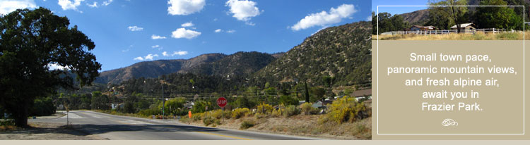
Frazier Park Living - Peaceful. Picturesque. Easy-going.
Frazier Park is a thriving mountain community of approximately 2,500 full and part-time residents who made their home here to enjoy the fresh air, picturesque mountain views, starry night skies, and the rural small town atmosphere that attracted the original settlers to the area back in the 1800’s.
Frazier Park is nestled inside the Los Padres National Forest and developed around a beautiful 28 acre community park dotted with California oak trees and a natural spring fed pond. The park offers fishing, barbeques, baseball diamonds, a children’s recreation area, an enclosed skate park, and a community club house. The park is the center for many annual events, celebrations, and activities in the mountain area.
Outdoor enthusiasts will enjoy living in the National Forest with over 1.7 million acres to explore and enjoy. Everything from endless scenic trails for hiking, biking, and off-road vehicles to streams, campsites, and cross-country skiing in winter are just minutes away. Wildlife is abundant during the spring, summer, and into the fall months – California quail, mule deer, hawks, owls, jays, blue birds, cotton tail and jack rabbit are just part of the Frazier Park landscape.
Frazier Park residents also enjoy year-around access to the 19,000 acre Hungry Valley State SVRA Park with its 130 miles of scenic trails for off-road vehicles. For mountain biking enthusiasts, the 8,000 acre Ballinger Canyon area is especially popular. You'll find 68 miles of routes that vary from sandy washes to ridgeline trails. The relatively dense route network provides many opportunities to make loops of varying dificulty. If you enjoy water sports, own a boat, or like to fish — Pyramid Lake is a few minutes south on Interstate I-5. Trails, fishing, kayaking, and camping are also available in nearby Lockwood Valley.
Frazier Park properties range in size from smaller lots with rustic mountain cabins to larger residential parcels with multi-level homes. Parts of Frazier Park are equestrian zoned and many residential properties around the down town area of Frazier Park are zoned for commercial giving residents the opportunity to establish home-based businesses.
Many Frazier Park homes are built on the north and south facing mountain slopes providing residents with unobstructed panoramic views. Homes located at higher elevations border the national forest. While Frazier Park offers many of the advantages of living in a larger town, it has maintained much of its original rural and rugged flavor. Main roads are paved and serviced by Kern County but many resident-owned roads remain graded and graveled.
The water in Frazier Park is delivered fresh from local aquifers and underground mountain springs by the resident-managed public water company. Frazier Park is part of the unincorporated area of Kern County. There are no homeowner association fees or formal covenants, conditions and restrictions (CC&Rs). The residents of Frazier Park have formed a town council and other public committees to oversee the affairs of the town.
Frazier Park residents enjoy a four-season climate with average temperatures ranging from 85° during the day to 62° at night in the summer and 55° during the day to 38° at night in the winter. The mountains are a great place to escape the Southern California summer heat. Expect mild summer temperatures with light breezes during the day and a natural cooling down in the evening hours. At an elevation of 4800 feet, Frazier Park can receive light to medium snowfall during the winter months – beautiful snow capped mountains are normally part of the winter scene in Frazier Park.
The downtown area offers mountain residents retail shopping, restaurants, markets, hardware stores, gas, banking, healthcare, a pharmacy, and other essential personal and professional services. A few minutes west, you’ll find the Pine Mountain Village with restaurants, a bakery, coffee house, gym, Pilate’s studio, hardware store, grocery and general store, gift shops and specialty stores, salons, and other personal and professional services.
The nearby towns of Lebec and Gorman offer fast-food restaurants, automotive services, a nursery, gas stations, a hay and feed store, and lodging. Frazier Park is just 5 minutes west of Interstate I-5 giving residents easy access to larger commerce centers located in Bakersfield and Valencia. For a complete list of businesses, services, and organizations in Frazier Park and the surrounding mountain communities, see Local Business Directory.
A beautification project has been completed in the center of downtown Frazier Park and a new 10,000 sq. foot public library is slated to break ground in September of 2009. Cuddy Creek that meanders through the valley of Frazier Park has received grants for restoration, bike paths, and other enhancements to make the creek more accessible and enjoyable to area residents and visitors.
Frazier Park provides a peaceful mountain retreat from the congestion, noise, and pace of suburban living. People move here to enjoy the small town atmosphere, fresh air, blue skies, clean water, four-season climate, and the natural beauty of the surrounding Los Padres National Forest. It’s a great place to raise children, own a retirement home or just a place to get away from it all.
Map of Frazier Park
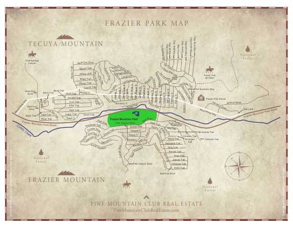
Click to Enlarge
Frazier Park Area Campgrounds, Hiking, ATV and 4x4 Trails
Frazier Park is home to many Los Padres National Forest Campgrounds, hiking and ATV trails including Salt Creek, Cherry Creek, McGill, Mt. Pinos, Chula Vista, Sheep, and Pleito. Trailheads are just a few minutes away for access on foot, ATV, 4x4, and horseback.
For maps and additional information on campgrounds, hiking and ATV trails in the Frazier Park area of the Los Padres National Forest, click on the following links.
Los Padres Forest Map — Local & Surrounding Area
Click Here
Los Padres Forest Map — Legend
Click Here
Los Padres National Forest Hiking Trail Information – Local
Click Here
Los Padres National Forest ATV Trail Information – Local
Click Here
Mt. Pinos Ranger Station
Mt. Pinos Ranger District
34580 Lockwood Valley Road
661-245-3731
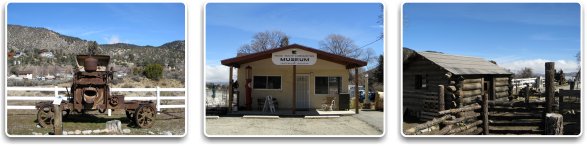
Frazier Park History - The Summer Village of the Chumash Indians.
The first settlement in the area of the future Frazier Park was a summer village of the Chumash Indian people. Located in a magnificent oak grove, it was at the base of the mountain they called “Toshololo.” Toshololo (Frazier Mountain) was one of the two holy mountains of this region, the other being Iwihinmu (Mt. Pinos) which was the Chumash sacred shrine. The village was called “wo’oht apaovea,” which meant the grasshopper’s watering hole or “Grasshopper Spring.”
The trails going through the mountains in this area were originally created by wild animals, which were worn deeper by the Indians and others in their passage from water hole to water hole. The Spanish “El Camino Viejo” (the old way) passed through the areas of Frazier and Cuddy Valley, paralleled the present Mil Potrero Highway, and continued down the San Emigdio Canyon. After leaving the canyon, the trail went up the west side of the San Joaquin Valley and on to the early Spanish capital of Monterey. This route from Los Angeles was the most commonly used trail in earliest recorded times.
In the 1850’s the area of Frazier Park became known as “Campo del Soldado” (Soldiers Field) when the men of Fort Tejon established an early lumber mill among the oaks to provide lumber for the building of the new military post.
John Cuddy, who had established a ranch just west of Lake of the Woods, acquired the future area of Frazier Park. When his son came of age, he built his home and barn in the area of today’s park.
The next influence to the future of the area was the Frazier brothers, who in 1870 established a very profitable gold mine on the south slope of the mountain that would soon bear their name.
By the early 1900’s, the oaks and pines around Mark Cuddy’s ranch were a popular mountain camping and vacation spot for the new automobile enthusiasts looking for places to drive away from the city.
When Marcus Cuddy and his wife Dessie divorced, the property was sold to developers from Glendale who envisioned a country club community, riding stables, golf course, clubhouse, seven lakes, and rustic mountain cabin sites. The Frazier Mountain Park Rod and Reel Club was established in 1925, but two of the lakes and the golf course were never constructed.
Markets, lumberyards, lunchrooms, and taverns soon followed, as did the post office and schools. Electricity arrived in 1927 but telephone service was not common until the 1950’s.
By 1930, the population of Frazier Mountain Park had grown to about 150 people but the Depression of the early 1930’s soon took its toll. The price of lots plummeted and the area filled up with bootleggers and gamblers.
Things started to change in the sparsely populated mountain town when the economy began to improve in the late 1930’s. Frazier Park was rediscovered by people from Southern and Central California passing through on the Grapevine. They bought lots and built homes, businesses opened to meet the demand of the growing population, and once again, the tiny town was its way to a brighter future.
For more historical information on Frazier Park, visit the Ridge Route Communities Museum and Historical Society in Frazier Park or by visiting the following website.
Ridge Route Communities Museum and Historical Society Website
Click Here
Frazier Park Area Schools
For families with children, Frazier Park is part of the El Tejon School District which covers a wide area including: Lebec, Lake of the Woods, Lockwood Valley, Piñon Pines, Cuddy Valley, and Pine Mountain Club. For more information on Frazier Park Schools and the El the Tejon School District, visit the following websites.
Average Temperatures
Spring |
67/48 |
Summer |
85/63 |
Fall |
75/60 |
Winter |
50/38 |
Area Information
Population: |
Approximately 2500 |
Elevation: |
4700-5000 feet. |
Snowfall: |
From ½ inch to 2 feet approximately 6 times a year |
Roads: |
Main roads are paved and maintained by Kern County. Residential roads are graded, graveled, paved, and privately maintained. |
Utility Information
Utilities: |
Water, power, phone and cable to each property. |
Television: |
Cable and Satellite. |
Internet: |
High Speed Wireless, Cable, Satellite, and DSL in some areas. |
Sewage: |
Septic System. |
Gas: |
Southern California Gas Company. |
Water: |
From artesian wells and aquifers. Resident-managed public water company. |
Public Services
Emergency
Medical: |
Private Ambulance Service and Kern Medical Helicopter. Two medical clinics. Major medical centers in Bakersfield and Valencia. |
Fire: |
Kern County Fire Department located in Frazier Park. Fire hydrants are located throughout the community. Los Padres National Forest Fire Service located just minutes away and lake water is available on Tejon Ranch for extraction. |
Police: |
Kern County Sheriffs Department located in Frazier Park. |
Schools: |
El Tejon School District. Elementary through High School in Frazier Park and Lebec. Pine Mountain Charter School is located in Pine Mountain Club. School bus service is provided by the district. |
Churches: |
There are many denominations in the area. See Local Directory under "Churches" |
Cities Nearby:
Valencia
Santa Clarita Valley: |
Distance—45 miles. For more information about, Valencia click the link below. |
|
|
Bakersfield
San Joaquin Valley: |
Distance—45 miles. For more information about Bakersfield, click the link below. |
|
|
Airports
Meadows Field
Bakersfield (BFL): |
Distance—52 miles. Nonstop flights to Denver, Los Angeles, Phoenix and San Francisco and one-stop service to hundreds of domestic and international destinations. The new William M. Thomas Air Terminal at Meadows Field is now open.
Visit the Meadows Field Airport Website by clicking the link below.
Click Here |
Bob Hope Airport
Burbank (BUR): |
Distance—64 miles. Nonstop flights to destinations throughout the United States. Served by most major carriers. One stop service to hundreds of international destinations.
Visit the Bob Hope Website by clicking the link below.
Click Here |
Los Angeles International
(LAX): |
Distance—79 miles. Nonstop flights to cities all over the World. Visit the Los Angeles Airport Website by clicking the link below.
Click Here |
Map of Frazier Park in Relation to Airports
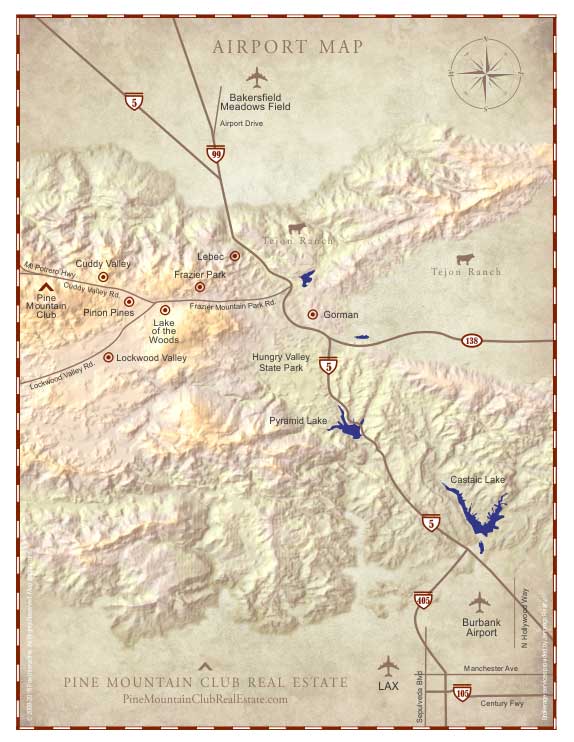
Click to Enlarge
Approximate Travel Times from Frazier Park
Los Angeles: |
65 minutes |
Bakersfield: |
65 minutes |
Santa Clarita: |
65 minutes |
Lancaster/Palmdale: |
45/60 minutes |
Santa Maria: |
95 minutes |
Ventura: |
95 minutes |
Santa Barbara: |
2 hours |
Pismo Beach: |
95 minutes |
San Luis Obispo: |
95 minutes |
Directions to Frazier Park – A scenic drive from any direction.
Regional Map
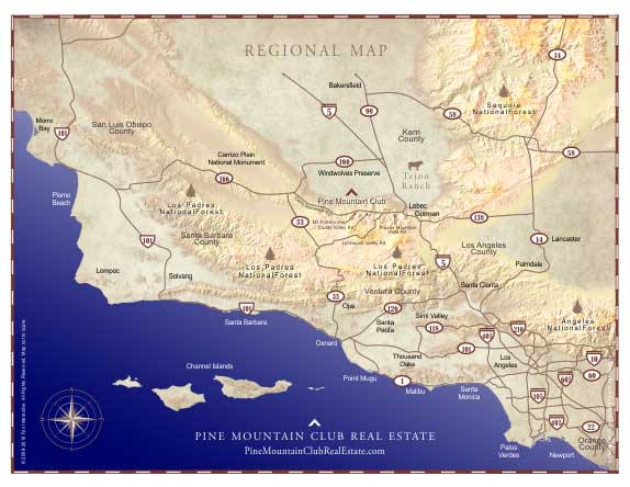
Click to Enlarge
From Interstate I-5
From either direction on I-5, take the Frazier Mountain Park Road Exit (205). Go west for 5 miles to Monterey Trail. You will now be located in the center of Frazier Park.
To reach our office, continue on Frazier Mountain Park Road. It will transition to Cuddy Valley Road. Bear right onto Mil Potrero Highway and drive 6 miles into Pine Mountain. Pine Mountain Village is on the left. You will see the Village Center sign at the corner of Mil Potrero Highway and Freeman Drive. Turn left on Freeman Drive and turn right on Pine Valley Lane into the Center. Continue on Pine Valley Lane until you see the Jennings Realty sign on the right.
From the California Coast & 101 Freeway
From either direction on the 101 Freeway, take the CA-166 exit. Take CA-166 east for approximately 70 miles. Turn right onto Cerro Noroeste Road and proceed for approximately 25 miles into Pine Mountain Club. Cerro Noroeste Road will become Mi Potrero Hwy. Continue on Mil Potrero Hwy until you reach Cuddy Valley Road. Turn left. Continue on Cuddy Valley Road until it transitions into Frazier Park Road. Follow Frazier Park Road to Monterey Trail. You will now be located in the center of town.
To reach our office, follow the same directions above. When you reach the Village Center in Pine Mountain Club, continue past the Center and turn right on Freeman Drive. Turn right on Pine Valley Lane into the Center. Continue on Pine Valley Lane until you see the Jennings Realty sign on the right.
Stop by the office and say hello or call me and I’ll take you on a personal tour. It would be my pleasure to show you around Frazier Park.
Frazier Park Homes and Land for Sale – See every property listed in the MLS.
For information on Frazier Park real estate, Frazier Park homes for sale, and available Frazier Park land for sale, follow the link below to search our listed properties in Frazier Park and the official Multiple Listing Service (MLS) that includes Frazier Park property listings provided by all local real estate offices.
Search Frazier Park Homes and Land for Sale
Click Here
For More information
If you have any questions about Frazier Park or would like more information on a Frazier Park property you see during your real estate search here or anywhere on the Internet, it would be my pleasure to assist you.
Credits
Bonnie Ketterl Kane. A View from The Ridge Route.
Our special thanks to Bonnie Ketterl Kane and the Ridge Route Communities Museum and Historical Society for providing information on the history of this community.