The Chumash Indians – History & Legend
The Chumash once numbered in the tens of thousands and were considered the elite or intelligentsia of the coastal natives. They were people of high integrity and lived in harmony with nature. Chumash astronomers charted the heavens and had their own solar and star charts. Astrologers interpreted those charts in guiding the everyday lives of the people.
Their territory encompassed 7,000 square miles - from the Channel Islands to Malibu up to Paso Robles and inland to the western edge of the San Joaquin Valley. Santa Barbara was the central point in their lands; Mt. Pinos (Iwihinmu) was their sacred shrine and the area of Mt. Pinos, Cuddy Valley (Valley of the Shaman) and Frazier Mountain (Toshololo) was the center of their universe.
With resources from both the land and the sea, The Chumash were able to enjoy a more prosperous environment than most other tribes in California. As hunters, gatherers and fishermen, they recognized their dependency on the world around them. Ceremonies marked the significant seasons that their lives were contingent upon with emphasis given to the full harvest and the storage of food for the winter months. During the winter solstice, the shaman priests led several days of feasting and dancing to honor the power of their father, the sun.
As the finest boat builders among the California Indians, the Chumash were one of the relatively few New World peoples who regularly navigated the ocean. They used plank canoes to travel up and down the coast and to the Channel Islands. Most archeologists who work with the Chumash culture believe the “Tomol” (plank canoe) was an indigenous invention. Other researchers suggest the Chumash may have been visited by Polynesians between AD 400 and 800. Their advanced sewn-plank canoe was used throughout Polynesia but is unknown in North America, except by the Chumash and Tongva.
The Chumash were accomplished traders, and had a monetary system based on beads and seashells. They traded herbs, baskets, tools and other artifacts with other tribes and bands in the spirit of sharing as opposed to one of profiteering.
Three basic laws guided the Chumash:
- Limitation - Each individual should recognize and accept his or her limitations and not envy those of others. Each member of the tribe should be happy in their abilities, for they all had equal value in the community.
- Moderation - Take only what you need from the land and the ocean. Leave some for future days and future peoples. The same goes for your tasks; better to take your time than make a mistake which would render all your work useless.
- Compensation - Give without expecting anything in return, give from the kindness of your heart and recognize the fact that compensation comes in many forms which are not always tangible.
The Chumash lived life in balance with nature and they were ready for any situation they would encounter in their daily existence and their tasks. As a spiritual people, their view of death also echoed wisdom, believing it to be a natural part of life, bringing forth renewal and allowing the spirits of those who had departed to carry on within the living through songs, dance, art, and storytelling.
Every object the Chumash created had a double purpose — a practical, utilitarian use and the spiritual expression of its power. They were physically and spiritually united with nature, and did not waste any part of any animal they killed, or any plant they pulled from the earth. They lived according to “nature’s time,” and believed that man’s great desire for supremacy could eventually lead to his downfall.
A matriarchal society, the Chumash traced their lineage from the mother’s side of the family. Men and women served equally as chiefs and priests. It was not uncommon for one chief to hold responsibility for several villages. The son or daughter could inherit this position of authority for the Chumash community when the chief died.
The Chumash were some of the first people to inhabit North America. Evidence was found that they had settlements on the Channel Islands and Santa Monica Mountains as far back as thousands of years ago. They were divided into two groups — the coastal people and the inlanders — and there were eight different language dialects.
The Rainbow Bridge—A Chumash Creation Legend
The story of the creation of the Chumash begins on Santa Cruz Island. Legend has it the Chumash were created from a seed planted by the earth goddess. For many years, the Chumash prospered until the land had become too populous for Santa Cruz Island. Ultimately the Earth Goddess decided that some of the people would have to move off the island to the mainland where there was plenty of space.
In order to get the people to the mainland, the earth goddess created a bridge out of a rainbow. It was a very large rainbow that stretched from the highest peaks of Santa Cruz Island to the mainland shore near modern-day Carpenteria.
The earth goddess told the people to cross the rainbow bridge and fill the world with people. Some of the Chumash made it across the bridge safely but some did not. The ones who looked down at the fog shrouded waters of the Pacific became dizzy and fell into the ocean. The earth goddess felt badly that these people had fallen, so she turned them into dolphins. That’s why the Chumash claim the dolphins are their brothers.
Chumash Rock Paintings
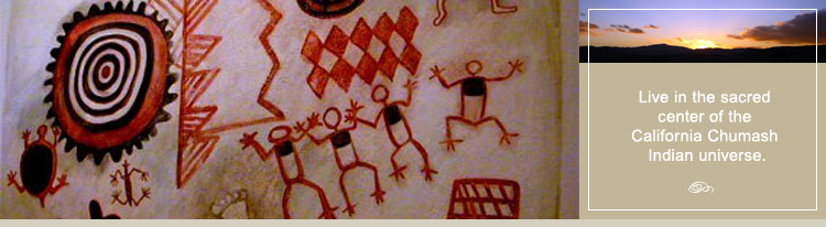
Chumash Cave Paintings are among the most elaborate and colorful in the world. They were neither art to be admired nor simple graffiti – they were probably made for religious reasons. Shamans, or Chumash priests, are thought to have made these paintings to influence supernatural beings and forces to intervene in human affairs. We can only guess what these mysterious symbols meant to their creators, but they may represent mythic figures, natural phenomena, or abstract concepts.
The earliest Chumash used charcoal for their drawings, but as their culture evolved, they colorfully decorated caves using, red, orange, black, white, and yellow pigments. These colorful yet simple cave paintings included human figures and animal life. They used a technique of applying dots around the figures to make them more distinct.
It’s hard to tell how old the paintings are. Most are probably less than 1.000 years old, and some are relatively recent. At Painted Cave, in the hills above Santa Barbara, the complex designs were painted at different times, often over those done previously. Without damaging the delicate paintings, experts have collected tiny pigment samples for dating and analysis. The results are consistent with one theory that this figure may represent a solar eclipse that occurred on November 24, 1677. Other figures were painted before and after that, in styles that changed through time.
There are many sites of Chumash rock paintings. These paintings are fragile and can be easily damaged. Because of the importance of preserving this irreplaceable cultural heritage and the fact that rock paintings remain sacred to Chumash people, these locations are not given out. One exception is Painted Cave State Historic Park near Santa Barbara.
Visit the Chumash Indian Painted Caves
The Chumash Painted Caves is a California Historic Park located about 12 miles northwest of Santa Barbara off of the San Marcos Pass Road or Highway 154. The caves are on Painted Cave Road, a very narrow and steep road that winds its way up the face of the Santa Ynez Mountains. The main cave is located on the left side of the road. There is very little parking except on the narrow shoulder of the road.
The cave is a few hundred feet up a trail, above the road. The cave entrance is covered with a metal screen. Inside are pictographs painted in bright colors on the cave walls by the Chumash Indians centuries ago. The paintings are believed to have religious meaning.
Take a short zoom lens and a flash to capture the paintings. There is also a steep trail that continues on up the hill from the main cave to presumably smaller caves. Pictographs and Chumash rock paintings.
California State Historic Park
Click Here
The Inland Chumash
The territories of several great nations of people came together in the San Emigdio Mountains. The area was the far northeastern territory of the Chumash people. The San Emigdiano Mountain People were called the Tokaya (Emigdiano) and the Chumash of the Castac Lake area were the Kashtiq. The different names reflect the different dialects spoken in their specific tribal lands. The Tokaya lived in and around the area of San Emigdio Canyon. The Castac Chumash were located in the area of Castac Lake (Lake Tejon) to the east of present day Interstate 5 and across from today’s community of Lebec.
Before any contact with Europeans, the population of the San Emigdio Mountains numbered from five to ten thousand. The Chumash were known to be peacefully inclined and further advanced in their crafts and community organization than most tribes.
The inland Chumash served as trade brokers between their people and the Natives of other areas. Fish and the treasures of the sea, the magnificent shells and shell beadwork, the basketry, the carved wood items, the furs and hides, and the art of their people were in great demand. Native traders came from all over the western region, and from as far east as the Colorado River, to barter for Chumash works, which were considered great prizes.
An annual Hutash Festival was held each fall following the harvest. This was the last opportunity for trade before the winter snows closed the mountain passes, and it was a great gathering and celebration. The Hutash Festival was the Chumash Pow Wow, and lasted for five or six days. All the shaman/astrologer priests gathered in closed ceremony to realign the cosmos and the world for the coming year. The business of the nation was conducted among great feasting, celebration and trade.
The Chumash people lived in a direct, simple relationship to one another, their land, the world and the universe. Every rock and tree, bird and beast, mountain and marsh had a spirit, as did the wind, the clouds and sky, the sun and the moon. It was believed that these spirits could communicate with one another.
The area of greatest spiritual significance to the coastal and mountain Chumash people encompassed two sacred mountains and the valley between them: Iwihinmu (Mt. Pinos), Toshololo (Frazier Mountain) and the valley of the “Antaps” or Shaman (Cuddy Valley).
The Shamans (Antaps) roles were of great importance in daily life as they served as healers, ceremonial specialists, astronomers, weathermen, religious practitioners, and leaders of community events. The Shaman would make an annual sojourn to the “Valley of the Antaps” (Cuddy Valley) to perform rituals. They would draw strength from the two sacred mountains at each end of the valley – the highest points in the Chumash lands. The tops of the two mountains allowed closeness to and the best view of the stars for the shaman astronomers to do their work.
Iwihinmu (Mt. Pinos) was the Chumash sacred shrine. The lower elevations of Iwihinmu were heavily forested with Piñon Pines that offered an abundance of pine nuts, but on the mountain itself, the Chumash would not gather the seeds. On the summit was a shrine, which no Indian would approach except to make an offering. Iwihinmu was held sacred by the earliest people because when looking the four directions from the summit; their entire world could be seen.
The Decline of the Chumash
As with most Native American tribes, the Chumash history was passed down from generation to generation through stories, dance, and legend. Many of these stories were lost when the Chumash Indian population was all but decimated in the 1700’s and 1800’s by the Spanish mission system.
Some scholars have suggested that the Chumash population may have declined substantially during a “protohistoric” period (AD 1542-1769) when there was intermittent contact with the crews of Spanish ships, including Juan Rodriguez Cabrillo’s expedition in AD 1542-43.
In 1769, a Spanish land expedition, led by Gaspar de Portola, left Baja California and reached the Santa Barbara Channel. In short order, five Spanish missions were established in Chumash territory. The Chumash population was eventually decimated, due largely to the introduction of European diseases. By 1831, the number of mission-registered Chumash numbered only 2,788, down from pre-Spanish population estimates of 22,000. By 1900, their numbers had declined to just 200.
The Chumash Today
Most Chumash are now a people without land to call their own. Only the Santa Ynez band has yet made the list of federally recognized tribes. There is still a Hutash Festival held each fall in the Santa Ynez Mountains above Santa Barbara and this gathering is open to the public.
Amongst native peoples, the Chumash are the most protective of their ways and spiritual beliefs. Photographs are not allowed at any time. They keep primarily to themselves, especially the elders and the tribal leaders. A few dancers are venturing into inter-tribal Pow Wows hosted by other tribes and are becoming more social. However, the traditional Chumash is still very guarded and wary of outsiders.
According to some reports, there are now some 5,000 people of Chumash. What an honor it is to live in the shadows of sacred Mt. Pinos and the land of the incredible Chumash.
More information
For more information on the Chumash Indian Tribe, visit the following Chumash Indian websites:
Chumash Indian Website
Click Here
Santa Barbara Museum of Natural History Website
Click Here
Chumash Indian Museum Website
Click Here
Santa Ynez Band of Chumash Indians Website
Click Here
Wishtoyo Foundation
Click Here
The Northern Chumash Tribal Council
Click Here