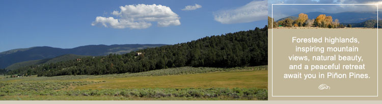
Piñon Pines Living – Forested highlands. Natural beauty. Inspiring views.
Piñon Pines is a quiet residential community nestled on a beautiful pine covered ridge in the heart of Cuddy Valley. Surrounded by the Los Padres National Forest and ranchland on all four sides, Piñon Pines offers dramatic views of the San Emigdio mountain range with sweeping views of highland meadows dotted with grazing cattle below.
The atmosphere is quiet and serene. It’s a place where you’ll feel a thousand miles away from the congestion and pace of the urban and suburban centers. A less-traveled place where you can relax and unwind, where the air is fresh, the skies are blue, the sunsets are take-your-breath-away beautiful, and the dark night sky turns into a canopy of a billion stars.
The four-season climate in Piñon Pines brings a multitude of native wild flowers, plants, and grasses in the spring. Mild summer days give way to cool evenings. Bright autumn colors appear in early September and winter mountain snows create a winter wonderland. Wildlife is abundant here in the spring, summer, and into the fall months. California quail, California mule deer, fox, jays, blue birds, cotton tail and jack rabbit are just part of the natural Pinion Pines landscape.
The scenic Los Padres National Forest encompassing nearly 2 million acres offers Piñon Pines residents immediate access to endless trails through some of the most beautiful public lands in California. A portion of Piñon Pines are zoned for horses and boarding is available in Cuddy Valley and Lockwood Valley. You’ll never have to worry about the threat of future development encroaching on the places you love to ride.
Residents of Piñon Pines also enjoy year around access to the 19,000 acre Hungry Valley State SVRA Park with its 130 miles of scenic trails for some serious off-roading. For mountain biking enthusiasts, the 8,000 acre Ballinger Canyon area is especially popular. You'll find 68 miles of routes that vary from sandy washes to ridgeline trails. The relatively dense route network provides many opportunities to make loops of varying dificulty. If you enjoy water sports, own a boat, or like to fish — Pyramid Lake is a just minutes south on Interstate I-5 and in neighboring Lockwood Valley, trails will take you to Piru Creek for fishing, kayaking, and camping. During the winter months, you can head up to the nearly 9000 foot Mt. Pinos summit for some of the best cross-county skiing in the United States.
The beauty of the landscape surrounding Piñon Pines has attracted many film companies over the years as the ideal backdrop for commercials, movie scenes, and episodes in popular television series. Piñon Pines, Cuddy Valley and the Mt. Pinos summit provided the perfect setting for the Ponderosa Ranch on the television series Bonanza in many episodes during the years of 1969-71. The most recent major film scenes shot in Piñon Pines area was for the 2003 movie “Van Helsing” staring Hugh Jackman and Kate Beckinsale.
Piñon Pines is home to approximately 200 custom built homes. Properties range in size from larger residential lots to multi-acre parcels. Piñon Pines homes range in size from 2-3 bedroom residences to expansive log and timber frame homes. Lots and acreage occasional appears on the market for people looking to build their own home. Piñon Pines is part of the unincorporated area of Kern County.
Average temperatures in Piñon Pines range from a high of 80° during the day to a low of 56° at night during the summer and a high of 60° during the day to a low of 35° at night during the winter months. Expect mild summer temperatures with light breezes during the day and a natural cooling down in the evening hours.
At an elevation of 5000-6000 feet, Piñon Pines occasionally receives light to medium snow fall during the winter months. Winter snow fall on the Cuddy Valley floor burns off quickly but remains much longer at the higher elevations creating views of snow capped Mt. Pinos, Frazier Mountain, and Tecuya Mountain.
The surrounding Los Padres National Forest offers residents of Piñon Pines protection from future development. The minimum subdivision on remaining undeveloped land surrounding the community is 20 acres without county and public approval and there is no commercial or industrial zoning in the greater Piñon Pines area that could threaten the environment or landscape.
All residential roads in Piñon Pines are paved and maintained by the Piñon Pines Property Owners Association. Homeowner association fees are affordable and formal covenants, conditions and restrictions (CC&Rs) apply. For CC&R information, contact the Piñon Pines Property Association at 661-245-5115. Electricity, telephone, and natural gas service is provided to each property.
The water in the Piñon Pines is provided by the resident owned mutual water company. The water in this area flows through artesian sand spring basins in the north part of the region and into underground aquifers. You’ll enjoy fresh spring water straight from the source without concerns about industrial and pharmaceutical contaminates.
Owning a home in Piñon Pines is about living to see, not living to be seen. It’s about negotiating scenic mountain trails, not freeways. It’s about living in the splendor of the beautiful forested highlands of Southern California, not the jungle. If you’re thinking of leaving the congestion behind for a peaceful retreat in a mountain setting, Pinion Pines is a wonderful place to call home.
Map of Piñon Pines
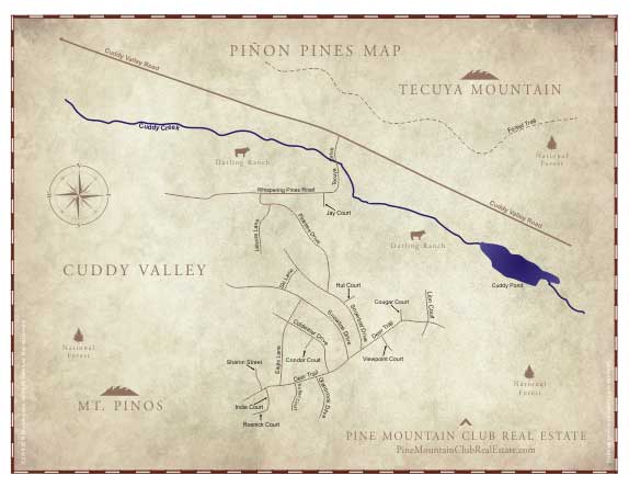
Click to Enlarge
Piñon Pines Area Campgrounds, Hiking, ATV and 4x4 Trails
Piñon Pines is home to many Los Padres National Forest Campgrounds, hiking and ATV trails including Salt Creek, Cherry Creek, McGill, Mt. Pinos, Chula Vista, Sheep, and Pleito. All trail heads connect to the Valley for access on foot, ATV, 4x4, and horseback. Two Los Padres National Forest Equestrian Campgrounds with corrals are located in neighboring Lockwood Valley for day or overnight use.
Reyes Creek Campground Information – Equestrian Corral
The Reyes Creek campground offers creek side camping that is seasonal — winter and spring. The elevation of the campground is at 4000 feet. Facilities include 30 camp sites with 1 pipe corral. No piped water is available. This Campground is a Campfire Use Site and requires an Adventure Pass for overnight camping.
The Reyes Creek campground is located 3 Miles east on Lockwood/Ozena Road off of Highway 33, then 1.5 miles from the turnoff on forest road 7N11 to Reyes Creek campground, which also goes to Camp Scheideck. The Scheideck settlement is tucked along Reyes Creek and was originally homesteaded in 1888. There are 30 to 40 cabins and a popular lodge, bar, and restaurant, which was built in 1898.
The campground offers easy access to the Gene Marshall-Piedra Blanca National Recreation Trail.
Thorn Meadows Campground Information – Equestrian Corral
The Thorn Meadows Campground is located in a shaded area among Jeffrey Pines. The elevation of the campground is 5000 feet. Facilities include 5 camp sites with 1 Pipe Corral. No piped water is available. There are 4 stoves, 4 tables and 1 restroom. This is a no fee campground.
The Thorn Creek Campground is located at end of the Spur Road, 9 Miles South off Lockwood Valley Road and 23 Miles West of Frazier Park.
For maps and additional information on campgrounds, hiking and ATV trails in the Piñon Pines area of the Los Padres National Forest, click on the following links.
Los Padres Forest Map — Local & Surrounding Area
Click Here
Los Padres Forest Map — Legend
Click Here
Los Padres National Forest Hiking Trail Information – Local
Click Here
Los Padres National Forest ATV Trail Information – Local
Click Here
Mt. Pinos Ranger Station
Mt. Pinos Ranger District
34580 Lockwood Valley Road
661-245-3731
Piñon Pines and Cuddy Valley History – The Chumash Valley of the Shaman.
The Chumash called today’s Piñon Pines and Cuddy Valley the “Valley of the Antaps” (Valley of the Shaman). It was an area of great spiritual significance. The Shaman would make an annual sojourn to the valley to perform rituals. Their purpose was to bring sacred powers down from the Upper World along a spiritual pathway to the Middle World, as it was felt that the two worlds were very close there.
The Shaman would draw strength from the two sacred mountains at each end of the valley, Iwihinmu (Mt. Pinos) and Toshololo (Frazier Mountain) – the highest points in the Chumash lands. They considered this area the center of their universe.
The Spanish used an inland trail that passed through Cuddy Valley. El Camino Viejo connected Los Angeles with the early Spanish capital of Monterey. What started as wild animal trails developed into a link between the Spanish missions.
The Butts family and the Cuddy family homesteaded the area in the 1800's. The Butts family operated a small cattle ranch on the land that is now Piñon Pines. The family remained on the property until the late 1930’s when the ranch was sold to the Schafer family. The Schafer’s lived on the land until the mid 1940’s when it was sold to the Cannon brothers and their sister Mary Brochtel. The brothers worked the land until the 1960’s when Steve Cannon was advised by his physician, Dr. McLaughlin that he should relocate to a lower elevation for health reasons.
Dr. McLaughlin purchased the land for a mere $20,000 with the intention to develop it into a residential community. Dr. McLaughlin encountered many problems while seeking county approval to subdivide the property and widen the main road leading into the development. Dr. McLaughlin retained the property until the 1970’s when he decided to sell the land to Eastco, Inc.
Eastco moved ahead with the Piñon Pines development when the company was abruptly stopped by an emergency measure signed into law, by then Governor Ronald Reagan, to halt planning of 35 land developments in Kern County. Representatives for Eastco challenged the law arguing that it did not apply to developments already in progress and that Eastco had already spent $200,000 on the residential project. The representatives, with the assistance of the author of the measure, were able to persuade the County that they had a right to move forward with the development. Piñon Pines was completed in 1975.
John Cuddy, for whom Cuddy Valley is named, came to the United States from Ireland during the Great Potato Famine. He joined the military and, after he was discharged in 1853, followed his unit to Fort Tejon as a civilian teamster. John soon became the chief herder for the fort and found a lush green meadow some 12 miles from the fort that was best for grazing. It was here that he built the log cabin which still stands today. The Cuddy family has continued its long tradition of raising cattle. The Cuddy family homestead can be seen along Lockwood Valley Road.
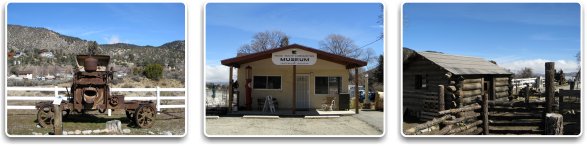
For more historical information on the Piñon Pines and Cuddy Valley area, visit the Ridge Route Communities Museum and Historical Society in neighboring Frazier Park or by visiting the following website.
Ridge Route Communities Museum and Historical Society Website
Click Here
Nearby Shopping – You won’t have to travel far.
Piñon Pines may feel remote but all the essentials are close by. Neighboring Frazier Park offers retail shops, restaurants, markets, gas, hardware stores, a pharmacy, and the personal and professional services you would expect to find in a larger city.
A few minutes west, you’ll find Pine Mountain Village with restaurants, a bakery, coffee house, gym, Pilate’s studio, hardware store, grocery and general store, gift shops and specialty stores, salons, and other personal and professional services.
Nearby Lebec and Gorman offer fast-food restaurants, automotive services, a nursery, gas stations, hay and feed store, and lodging. For more information on the businesses and services available in the mountain area, see Local Business Directory.
Piñon Pines Area Schools
For families with children, Piñon Pines is part of the El Tejon School District which covers a wide area including Pine Mountain Club, Frazier Park, Lake of the Woods, Lockwood Valley, Cuddy Valley, and Lebec. School bus service is provided to Cuddy Valley. For more information on Piñon Pines area Schools and the El the Tejon School District, visit the following websites.
Average Temperatures
Spring |
62/48 |
Summer |
80/56 |
Fall |
72/42 |
Winter |
55/35 |
Area Information
Population: |
Approximately 250 |
Elevation: |
5000-6000 feet. |
Snowfall: |
From ½ inch to 2 feet approximately 8 times a year |
Roads: |
Main roads are paved and maintained by Kern County. All residential roads are paved and maintained by the Piñon Pines Property Owners Association. |
Utility Information
Utilities: |
Power, phone, and cable available to each property. |
Television: |
Cable and Satellite. |
Internet: |
High Speed Wireless, Cable, and Satellite. |
Sewage: |
Septic System. |
Gas: |
Southern California Gas Company |
Water: |
Piñon Pines Mutual Water Company |
Public Services
Emergency
Medical: |
Private Ambulance Service and Kern Medical Helicopter. Two medical clinics in nearby Lebec and Frazier Park. Major medical centers in Bakersfield and Valencia. |
Fire: |
Kern County Fire Department is located in Frazier Park. Los Padres National Forest Fire Service is located minutes away and lake water on Tejon Ranch is available for extraction. |
Police: |
Kern County Sheriffs Department services the area from Frazier Park. |
Schools: |
El Tejon School District. Elementary through High School in Frazier Park and Lebec. Pine Mountain Charter School is located in Pine Mountain Club. School bus service is provided by the district. |
Churches: |
There are many denominations in the area. See Local Directory under "Churches" |
Cities Nearby:
Valencia
Santa Clarita Valley: |
Distance—48 miles. For more information about, Valencia click the link below. |
|
|
Bakersfield
San Joaquin Valley: |
Distance—48 miles. For more information about Bakersfield, click the link below. |
|
|
Airports
Meadows Field
Bakersfield (BFL): |
Distance—45 miles. Nonstop flights to Denver, Los Angeles, Phoenix and San Francisco and one-stop service to hundreds of domestic and international destinations. The new William M. Thomas Air Terminal at Meadows Field is now open.
Visit the Meadows Field Airport Website by clicking the link below.
Click Here |
Bob Hope Airport
Burbank (BUR): |
Distance—65 miles. Nonstop flights to destinations throughout the United States. Served by most major carriers. One stop service to hundreds of international destinations.
Visit the Bob Hope Website by clicking the link below.
Click Here |
Los Angeles International
(LAX): |
Distance—80 miles. Nonstop flights to cities all over the World. Visit the Los Angeles Airport Website by clicking the link below.
Click Here |
Map of Piñon Pines in Relation to Airports
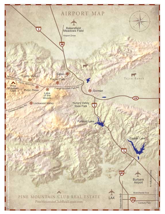
Click to Enlarge
Approximate Travel Times from Piñon Pines
Los Angeles: |
70 minutes |
Bakersfield: |
50 minutes |
Santa Clarita: |
50 minutes |
Lancaster/Palmdale: |
50/70 minutes |
Santa Maria: |
95 minutes |
Ventura: |
95 minutes |
Santa Barbara: |
95 minutes |
Pismo Beach: |
95 minutes |
San Luis Obispo: |
95 minutes |
Directions to Piñon Pines – A scenic drive from any direction.
Regional Map
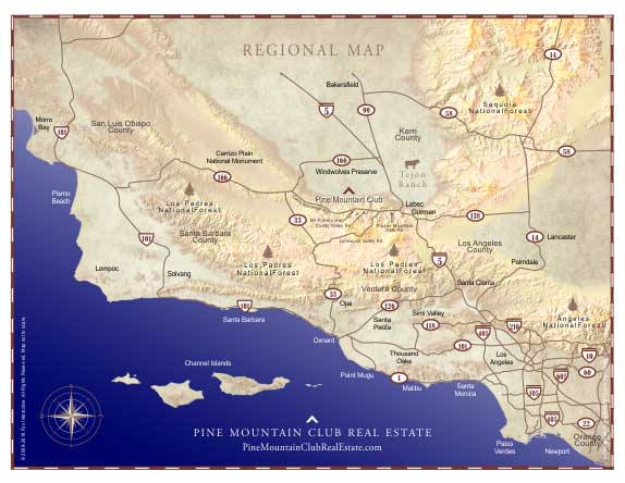
Click to Enlarge
From Interstate I-5
From either direction on I-5, take the Frazier Mountain Park Road Exit (205). Go west for about 9 miles. Frazier Mountain Park Road will become Cuddy Valley Road. Turn left on Tecuya Road to explore Piñon Pines.
To reach our office, continue on Cuddy Valley Road past Darling Ave. and turn right onto Mil Potrero Highway. Drive 6 miles into Pine Mountain. Pine Mountain Village is on the left. You will see the Village Center sign at the corner of Mil Potrero Highway and Freeman Drive. Turn left on Freeman Drive and turn right on Pine Valley Lane into the Center. Continue on Pine Valley Lane until you see the Jennings Realty sign on the right.
From the California Coast & 101 Freeway
From either direction on the 101 Freeway, take the CA-166 exit. Take CA-166 east for approximately 70 miles. Turn right onto Cerro Noroeste Road and proceed for approximately 25 miles into Pine Mountain. Cerro Noroeste Road becomes Mil Potrero Highway. Continue on Mil Potrero Highway until it ends at Cuddy Valley Road. Turn left on Cuddy Valley Road and then turn right on Tecuya Road to enter Piñon Pines.
To reach our office, follow the same directions above. When you reach the Village Center in Pine Mountain Club, continue past the Center and turn right on Freeman Drive. Turn right on Pine Valley Lane into the Center. Continue on Pine Valley Lane until you see the Jennings Realty sign on the right.
Stop by our office or let me know when you’ll be visiting the area. It would be my pleasure to show you around Piñon Pines and all it has to offer.
Piñon Pines Homes and Land for Sale – See every property listed in the MLS.
For information on Piñon Pines real estate, Piñon Pines homes for sale, and available Piñon Pines land for sale, follow the link below to search our listed properties in Piñon Pines and the official Multiple Listing Service (MLS) that includes Piñon Pines property listings provided by all local real estate offices.
Search Piñon Pines Valley Homes and Land for Sale
Click Here
For More information
If you have any questions about Piñon Pines or would like more information on a Piñon Pines property you see during your real estate search here or anywhere on the Internet, it would be my pleasure to assist you and share my knowledge of this wonderful community.
Credits
Bonnie Ketterl Kane. A View from The Ridge Route.
Our special thanks to Bonnie Ketterl Kane and the Ridge Route Communities Museum and Historical Society for providing information on the history of this community.